Use of Survey123 and 360 still images in Geographical Investigation (GI)
Presenter: Madeline Chen | NUS High School Link
Contents of Sharing:
Use of Survey123 as a tool to structure students' fieldwork experiences ('direct the gaze')
Design of classroom instruction complementing the use of 360 VR and GIS maps as learning materials
Assessment considerations in the age of AI
Context & Overview of Lesson Execution:
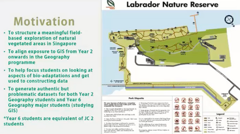
The GI package was designed with 2 groups of students in mind - Year 2 Geography students as well as Year 6 Geography major students studying GIS.
The package was a combination of topics, including: (1) Weather & Climate and (2) Natural Vegetation.
The generation of "problematic" datasets — e.g. temperature readings being higher at places with vegetation — is intentional.
This enables students to have real-life experience of cleaning and analysing data, just like what data scientists do.
Having students realise that there is often no perfect alignment of theory and practice also promotes critical thinking, where students need to make meaning of data and come to reasoned conclusions.
Pre-Fieldwork:
Students were tasked to conduct a literature review. Students conducted self-initiated research, on top of the recommended readings provided. (*Possible application of ChatGPT: students were directed to get ChatGPT to provide them with a list of references relevant to their investigation.)
They also had access to 360° media resources (stills and video) to familiarise themselves with the field site.
Actual Fieldwork:
Students' primary data collection included taking photographs, as well as completing an online survey form (see below), where they record weather variables as well as visual sightings of various parameters relating to natural vegetation.

Post-Fieldwork:
The field data collected through the online survey form were designed to allow students to draw simple correlations - e.g. direct/inverse relationship between ‘quality of environment’ (based on weather parameters) and the number of seedlings/propagules.
The data collected by the class was represented on a map (visualisation done by the teacher).
Triangulation Approach
I was inspired by how the teacher taught the students to "triangulate" their data - they corroborated their findings by cross-referencing against multiple data sources - e.g. temperature readings from weather tracker; field observations, photographs, as well as 360° images.
An example:

Role of Teacher?
Looking at the field data, students concluded that the presence/concentration of flowers at the fortress area (see below) meant that the state of the health of the forest is better than the mangrove area. The role of the teacher in this instance would then be to provide background context to deepen learning, e.g. sharing about the history of the fieldsite.

Madeline shared that the mangrove area (i.e. Berlayer Creek)was fully cleared of its natural vegetation in the last 70 years, and hence most vegetation on site are only 50-70 years old. On the other hand, vegetation in the fortress area was mostly spared, though some parts were still cleared for the building of the fort.
Data Analysis: Video
Teacher's Reflection on Fieldwork Execution


I am inspired by this! Getting students to annotate on maps as part of data analysis and sense-making. I have never thought of this, but I believe this would be a good stepping stone, with the next step being getting students to express their findings from analysing the maps in prose.

Madeline also shared that there are 'safeguards' in her marking rubrics when she suspects that students used AI to complete the data analysis part of their field report. E.g.
these students would be marked down for "coherence and organisation" if the work seem to be AI-generated.


Comentários